
Cal Fire recently released updated Fire Hazard Severity Zone (FHSZ) maps, and the changes may have significant implications for homeowners in the East Bay. These maps classify areas based on wildfire risk, and local officials are now tasked with adapting to the new designations. Let’s take a look at what this means for East Bay residents and how cities are responding.
What are Fire Hazard Severity Zones (FHSZ)?
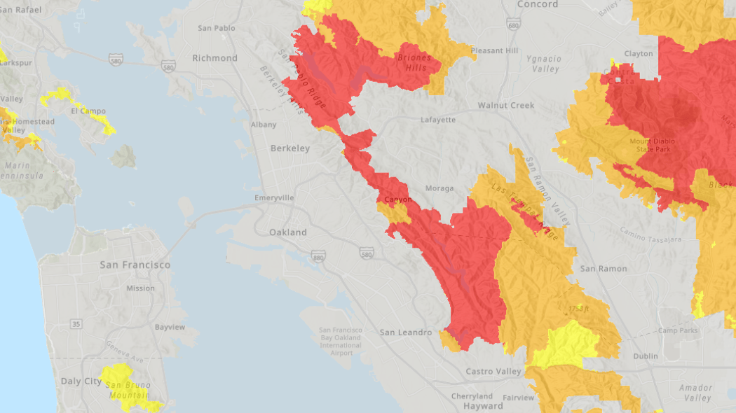
Cal Fire's FHSZ maps categorize areas into three levels of wildfire risk: Moderate, High, Very High.
These designations are based on factors like topography, vegetation, weather patterns, and historical fire data. The maps primarily cover wildland areas adjacent to urban zones, not dense city centers. The updated maps are intended to improve wildfire preparedness, inform local building codes, and encourage better fire safety practices.
Changes in the East Bay
The new maps have brought some relief to parts of the East Bay, while highlighting ongoing wildfire risks in certain neighborhoods:
Berkeley: The area classified as "Very High Fire Hazard Severity Zone" in Berkeley has shrunk significantly from 1,269 acres to 454 acres. Despite this reduction, Berkeley is not letting its guard down. The city is encouraging homeowners to phase out wood-shingle roofs, expanding firebreak zones in the hill neighborhoods, promoting home hardening strategies like installing ember-resistant vents and fire-resistant landscaping.
Oakland: Oakland also saw a 35% reduction in its "Very High" hazard zones, thanks to updated modeling and improved mitigation efforts. However, Oakland remains vigilant, continuing to require:
-
Annual wildfire district inspections to ensure that homeowners are maintaining defensible space around their properties.
-
Enforcement of fire safety codes, including clearing overgrown vegetation and securing flammable structures.
San Leandro has updated its fire severity zone maps and is in the process of adopting these designations into local ordinances. Similarly, other East Bay cities are evaluating and integrating these updated maps to align with state guidelines.
What This Means for Homeowners
If your property is within one of the newly designated hazard zones, here’s what you need to know:
-
Building codes: Properties in "High" or "Very High" zones may need to comply with stricter building standards, especially for roofing, windows, and siding materials.
-
Insurance costs: Some insurers may adjust rates or coverage based on wildfire risk classifications—check with your provider.
-
Defensible space requirements: Maintaining a buffer of at least 30 feet around your home (clearing dry brush and flammable plants) might be required.
For homeowners not previously in a hazard zone, this is a chance to evaluate your fire safety measures and ensure your home is prepared. Homeowners can check their property’s designation by visiting the Cal Fire website. Homeowners should also keep an eye on city announcements as local governments work to update building codes and fire regulations.
Taking Action
Whether your home is in a new hazard zone or not, fire safety is always a smart investment. Take steps now to:
-
Clear flammable plants and debris.
-
Upgrade to fire-resistant materials where possible.
-
Create an emergency evacuation plan for your family.
The new maps may bring some peace of mind for certain homeowners, but they also serve as a reminder that wildfire risk remains a reality in the East Bay. By staying informed and prepared, you can protect your home and your community.
Thinking about buying or selling in the East Bay? Contact us for expert insights into the latest market trends and how these changes might affect your property.
To access the updated FHSZ maps and determine the designation of your property, you can visit Cal Fire's official website. Additionally, local city websites, such as San Leandro's, offer resources and information on how these maps are being implemented at the municipal level.
By understanding your property's classification within these updated fire hazard severity zones, you can take proactive steps to mitigate wildfire risks and ensure compliance with any new regulations that may be adopted in your area.